目次 / Contents
1) 田代ロープウェー / Tashiro Ropeway
1) 田代ロープウェー / Tashiro Ropeway
A. 苗場 / Naeba
B. 乗車 / Getting On
2) 二居湖 / Lake Futai
A. ロープウェーとダム / Ropeway and Dam
B. 揚水発電所 / Pumped Storage Power Generation
C. 山の秘密? / Mountain Secret?
1) 田代ロープウェー / Tashiro Ropeway
A. 苗場 / Naeba
 |
'苗場ドラゴンドラ・田代ロープウェー' 私と夫Rは、苗場の紅葉を見に行くツアーに参加しました。 このツアーのメインは、'苗場ドラゴンドラ・田代ロープウェー'に乗り、 紅葉を見ることです。 私達のツアーは、田代ロープウェーを使用し、 山頂へ上り、ドラゴンドラで麓に下ってきました。 もちろん、その逆も可能ですが、ドラゴンドラで下ってくる方が 景色が楽しめるように感じます。 公式サイト : ★ 'Naeba Dragondola Tashiro Ropeway' I and my husband R took a tour to see the autumn colours in Naeba in Yuzawa, Niigata Prefecture. The main part of this tour is to take the 'Naeba Dragondola Tashiro Ropeway' and see the autumn colours. Our tour used the Tashiro Ropeway to climb the summit and down to the foot of the Dragondola. Of course, the reverse is also possible, but I feel that the scenery is more enjoyable when descending with Dragondola. |
 |
| 赤い部分:新潟県 Red Part : Niigata Prefecture 画像は下記より / This from below ★ |
 |
| 黄色の部分 : 南魚沼郡湯沢町 Yellow Part : Minami-Uonuma Yuzawa 画像は下記より / This from below ★ |
 |
| パンフレット表・裏 Leaflet Front and Back in Japanese |
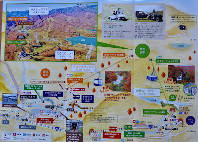 元々は苗場スキー場として開発された場所です。 (今もって、メインはスキーシーズンですよね) その後、一日楽しめるようにこの地域を 開発したことがわかります。 とは言っても、ゴルゴンドラは期間限定です。 私達のツアーは、日帰り旅行なので、 メイン部分だけ利用しました。 |
| It was originally developed as a Naeba ski resort. (Still, the main season is skiing, right?) I can see that they have developed this area so that we can enjoy it all day long. That said, the Dragondola is for a limited time. Since our tour is a day trip, we used only the main part.  ガイドさんの手書き説明入り With guide's handwritten explanation in Japanese |
B. 乗車 / Getting On
 |
| 田代ロープウェー 地上230mという日本一高い地点を通るロープウェーです。 Tashiro Ropeway This ropeway passes through the highest point in Japan, 230m above the ground. 91 people can get on.  |
ロープウェーからの写真全て、ガラス越しの撮影です。
なので、レフレクション(反射)が入っています。
All photographs from the ropeway were taken through the glass.
Therefore, they contain reflections.
 |
出発! / Departure! 二居川 (フタイガワ) が見えます。 この川で、渓流釣りをする人もいるそうです。 You can see the Futai River. Some people go mountain stream fishing in this river. |
 |
| ロープウェイの床の窓から 紅葉シーズンの中で、良い時期に感じました。 From Floor Window of Ropeway I felt it was a good time during the autumn colours season. |
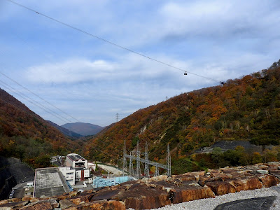
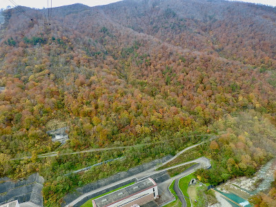 奥清津発電所 (オクキヨツ ハツデンショ) と 二居ダム が下〜の方に見られます。 |
| 地上230m地点ですが、最もそれが感じられる所では、 怖くて撮影ができない、ヘタレな私です。 The Oku Kiyotsu Power Station and Futai Dam can be seen at the botto~~m. It's 230m above the ground, and the place where I felt it I was scared and couldn't take a photograph.  二居ダム あとで、二居ダムにも行きました。 Futai Dam Later, we also went to Futai Dam. |
山頂到着 / Arrive at the Summit
 |
| 山頂から/ From Summit |
 |
| 山頂の案内図 / Guide Map at the Summit |
 |
| ドラゴンドラ山頂駅に 向かって歩きます。 Walk down towards Dragondola Summit Station. |
 |
| 田代湖 田代湖 (タシロコ) は、カッサダム建設によって できた人造湖です。 下池・二居ダム との間で水の往来させて 最大160万キロワットの電力を作ります。 Lake Tashiro Lake Tashiro is an artificial lake created by the construction of the Kassa Dam. Water is sent to and from the lower reservoir Futai Dam to generate up to 1.6 million kilowatts of electricity.  人造湖と聞いて興ざめするのは、私だけでしょうか? Rは逆に感動するらしい...。 When we knew this is an artificial lake, am I the only one who feels a chill cast over me? R, on the contrary, seems to be impressed ... |
2) 二居湖 / Lake Futai
A. ロープウェーとダム / Ropeway and Dam
ツアーの最後に訪れたのが二居ダムです。
二居ダムの前にゴルゴンドラに乗りましたが、そこでの撮影した写真が多いので、つ後のセクションに載せました。
二居ダムは、田代ロープウェー山麓駅のすぐ近くにあります。
At the end of the tour, we visited Futai Dam.
We got on the Dragondola before Futai Dam, but since I took many photographs from Dragondola, I will post them in the next section.
Futai Dam is very close to Tashiro Ropeway Sanroku (foot of Mountain) Station.
 |
| 田代ロープウェーからの二居ダムと二居湖 Futai Dam and Lake Futai From Tashiro Ropeway  田代ロープウェーは左上空を通っています。 The Tashiro Ropeway passes through the upper left sky. 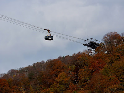 |
 |
| 二居湖 '二居湖' もしくは、'二居調整池' です。 清津川 (キヨツカワ)を堰き止めています。 なので、清津川の一部でもあります。 Lake Futai It is "Lake Futai" or "Futai Retention Pond". It is blocking the Kiyotsu River. Therefore, it is also a part of the Kiyotsu River. |
B. 揚水発電所
Pumped Storage Power Generation
 |
| 二居ダム記念碑 二居ダムは、信濃川水系清津川に建設されたダムです。 着工は1972年、竣工は、1978年です。 高さ87mのロックフィルダムです。 コンクリートを主体とするコンクリートダムとは異なり、 天然の土砂や岩石を盛り立てて築いた構造物です。 Futai Dam Memorial Futai Dam is constructed on the Kiyotsu River of the Shinano River system. Construction started in 1972 and completed in 1978. It is a 'Rockfill Dam' (Embankment Dam) with a height of 87m. Unlike concrete dams, which are mainly made of concrete, rockfill dams are structures built by heaping natural earth and sand and rocks. |
 |
| 奥清津発電所公式サイト : ★ Oku Kiyotsu Power Station Official Website : ★ (only in Japanese)  |
 |
| 左:上池・カッサダム(田代湖) 右:下池・二居ダム (二居湖) 右下のキャラクターは、この発電所のオリジナルのマスコット: 'オッキー' です。 Left : Upper reservoir / Kassa Dam (Lake Tashiro) Right : Lower reservoir / Futai Dam (Lake Futai) The character on the bottom right is the original mascot of this power plant, 'Okky'. |
日本最長の信濃川は、長野県を過ぎて、新潟県を流れる間にも多くの支流が合流します。
山間部は豪雪地帯で地形的に急流を作ることから多くの水力発電所があります。
二居ダムもそのうちの1つ、奥清津第二発電所の増設 (1996年竣工) によって、最大出力は合計で160万キロワットとなり、日本で最大級の揚水発電所 (ヨウスイ ハツデンショ) となりました。
 |
揚水発電の模式図 下記と画像は、Wikiより "電力需要が下がる深夜等の余剰電力で 下部貯水池から上部貯水池へ水の汲み上げを行い、 昼間・夕方などの高需要時間帯に 上部から下部へ水を流し発電することで需給調整を行う。" Schematic Diagram of Pumped Storage Power Generation The following and images are from Japanese Wiki "With surplus electricity such as at midnight, when electricity demand falls, water is pumped from the lower reservoir to the upper reservoir, and during high demand hours such as daytime and evening, water is flowed from the top to the bottom to generate electricity and thus adjusts between the supply and demand. " |
 |
| 赤い部分 : 長野県 新潟県はこのセクション上部の地図を参照のこと。 Red Part : Nagano Prefecture For Niigata prefecture, see the map at the top of this section. 画像は下記より / This from below ★ |
Japan's longest Shinano River flows through Nagano Prefecture, and many tributaries merge while flowing through Niigata Prefecture.
There are many hydroelectric power plants in the mountains
because of the heavy snowfall and fast flowing rivers in the mountain topography.
With the expansion of the Futai Dam, one of them,
the Oku Kiyotsu the second Power Plant (completed in 1996),
the total maximum output was 1.6 million kilowatts, making it one of the largest pumped storage power plants in Japan.
 |
Schematic diagram of pumped storage power generation The following and images are from the Wiki "Diagram of the TVA pumped storage facility in Tennessee, USA" This from below |
C. 山の秘密? / Mountain Secret?
 |
| "Okky (オッキー)" ・奥清津発電所 私達は行きませんでしたが、博物館もあります。 発電所建屋がそのままピーアール館・'Okkyミュージアム' になっていて、無料かつ事前申し込み手続きも不要で 発電所内を見学できます。 Rはすごく行きたがっていました...残念でしたね。 そう願っていたのは、Rくらいかも? "Okky" ・Okutsu Power Station We didn't visit, but they have a museum. The power plant building is the PR building / 'Okky Museum', and you can tour the power plant for free and without any prior application procedure. R really wanted to visite ... sorry. Maybe R was the only one who wanted that. Museum Official Website : ★ (only in Japanese) |
 |
| 下記、プリンスホテルのサイトより "二居湖は、天候・水量などにより七色に 色が変化する神秘的な湖です。" According to Prince Hotel Website, "Lake Futai is a mysterious lake that changes its colours to seven colours depending on the weather and the amount of water." (Translated by me) 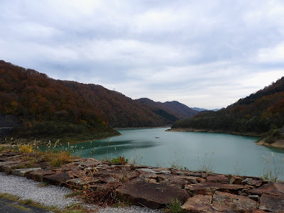 なんとなく、人工的な雰囲気はありますね。 Somehow, there is an artificial atmosphere, isn't it? |
 |
| ツアーのバス お世話になりました。 ありがとうございました。 Tour Coach Thank you very much. |




0 件のコメント:
コメントを投稿