有明海を渡る / Crossing the Ariake Sea
 |
島原ターミナル
フェリーの時間に制約されて、グラバー園見学の時間が短かかったのです。
Shimabara Terminal |
 |
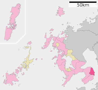
| 島原市は濃いピンク色の部分。 Shimabara City area is a dark pink part. 画像は下記より / This from below ★ |
渡り、熊本港まで行きました。
九州最大の川である筑後川をはじめ、たくさんの川が流れ込んでいるので、塩分濃度が低下します。
干満の差は6mで日本で一番あります。
有明研究プロジェクト: ★
有明海苔も有名ですよね。
 |
有明海 / Ariake Sea 画像は下記より / These from below ★ |
After Nagasaki Peace Park, we travelled across the Ariake Sea on a ferry with our bus from the Shimabara Port to the Kumamoto Port.
Ariake Sea is surrounded by Fukuoka, Saga, Nagasaki and Kumamoto Prefecture, it is the largest bay in Kyushu.
The area is 1,700km². (Tokyo Bay : 1,380km² / Ise Bay : 1,780km².)
The Chikugo River, the longest river in Kyushu and many other rivers flow into Ariake Sea, so the salinity concentration of the Sea becomes low.
The range of the tide is 6m which is the most in Japan.
The Chikugo River, the longest river in Kyushu and many other rivers flow into Ariake Sea, so the salinity concentration of the Sea becomes low.
The range of the tide is 6m which is the most in Japan.
The mudskipper is only in Ariake Sea and a part of the Yatsushiro Sea in Japan.
Including a mudskipper, there are 23 kinds of rare creatures which are only here in Japan.
Sriake Research Sea Project : ★
Sriake Research Sea Project : ★
The Nori ; edible seaweed of Ariake is famous, too. →Nori : ★
 |
ムツゴロウ
私は実際のムツゴロウをまだ見たことがありません。
Mudskipper (Boleophthalmus pectinirostris)
I
haven't seen a real Mudskipper yet.
画像は下記より /
This from below |
 |
| 眉山 (マユヤマ) 眉山は、七面山(標高818.7 m)、天狗山(695 m)、南峰(708 m)の総称です。 雲仙岳の東山麓に付属しています。 1792年 に火山性地震が山体崩壊を招き、その跡 (地肌) が見られます。 そして現在もその崩壊は続いているとか.... Mount Mayuyama It has three parts, Mount Shichimensan ; 818.7 m, Mount Tenguyama ; 695 m, Nanpo Ridge ; 708 m. It attaches to the East of Mount Unzen. In 1792 there was a volcanic earthquake which made a collapse of the then volcanic edifice. We could see the mark ; the ground surface. I heard it is still collapsing today..... |
 |
| 雲が眉山を覆っています。 The clouds cover Mount Mayuyama. |
 |
| ここからバスに乗ったまま乗船しました。 Here we got on the ferry while we sat down in the coach. |
 |
オーシャンアロー、かっこいい船です!
オーシャンアローはカーフェリーで、超細長双胴船 (SSTH)と呼ばれる船型を
採用した高速の双胴船です。
SSTH Ocean Arrow is a cool ferry!
SSTH OceanArrow is
a super slender twin hull (SSTH) car ferry operating.
This
is run by Kumamoto Ferry : ★.
The
trip takes about 30 minutes, or about half the time that it had
previously taken.
We
got on a normal ferry : ★ :
'Ferry Aso' which is run by Kyushou
Ferry. |
 |
| 島原港を離れて行きます。 We are leaving Shimabara port. |
 |
| どこにでもいるカモメ、いつも撮ってしまう... Seagulls are everywhere, I always photograph....  でも、飛ぶ姿を撮影できるのは珍しい。 But it is unusual for me I could photograph them flying. |
 |
泥色?
大昔(8万年前)、阿蘇山 (アソザン) が噴火した時に
地下からふき出てきた泥が、潮の流れでつねにまき上げられて、
有明海は泥の色に見えると言われています。
でも、結構青いです。
Mud
Colour?
They
say a long long time ago (80 thousand years ago)
Mount
Aso had eruptions
and mud came out from the earth
which is still lifted by currents so that sea colour looks mud coloured.
But
it looks quite blue. |
 |
| オーシャンフェリーが私達のあとからやって来て、 追い抜いて行きました。 'Ocean Arrow' was coming after us and overtook us. |
 |
| 'オーシャンフェリー'と'フェリーあそ' 'Ocean Arrow' and 'Ferry Aso'  |
 |
| 'フェリーあそ' 私達が乗っている船と同じ型です。 'フェリーあそ'は1時間で熊本港-島原港を結びます。 'Ferry Aso' This is the same our ferry type. 'Ferry Aso' takes one hour between Kumamoto and Shimabara. |
 |
| 熊本港のライトブイ (灯浮標 /トウフヒョウ) Light buoy in Kumamoto Port |
 |
| どの山が金峰山 (キンポウザン)でしょう? 右の山らしい... Which mountain is Mount Kinpouzan? It seems to be the right one....  この写真では左 / Left on this photo |
 |
| 海苔の養殖場 有明海の海苔は支柱式養殖で作らています。→★ Nori Farm? Ariake Sea Nori makes by the pole system.→★ |
 |
熊本港 / Kumamoto Port
山はおそらく金峰山
緑の屋根が熊本ターミナル
The
mountain is probably Mount Kinpouzan.
Green
roofs are KumamotoTerminal   まもなく、到着 / Focking Soon |


0 件のコメント:
コメントを投稿