
 |
| 熊野・南紀旅行 11月12 - 14日 Kumano and Nanki Trip 12 -14th of November Kii Peninsula Trip |
| 第2日目予定 / Schedule for the Second Day |
 |
熊野古道 Map of Kumano Kodō : Map of the Old Roads of Kumano in Kii Peninsula, in Japanese ★ |
 |
Kii Peninsula Map of Kumano Kodō : Map of the Old Roads of Kumano (Medieval pilgrimage routes) Red icons are shrines and a temple that the roads begin and terminate at. 画像は下記より / This from below |
目次 / Contents
1) 大門坂 / Daimonzaka-hill
2) 大門坂へ入る / Enter to Daimonzaka-hill
3) 九十九王子? / Ninety-nine Princes ?
4) 杉並木 / Cedar Avenue
5) 八咫烏のデザイン / Yatagarasu Design
A. 駐車場の八咫烏 / Yatagarasu in Carpark
B. シンボルマーク / Symbol Mark
1) 大門坂 / Daimonzaka-hill
私がこのツアーに参加した一番の理由は、
「熊野古道を歩きたい!」
と思ったからでした。
ですが、ツアーでは、体への負担が少なく、時間も取りすぎないように配慮され、私達は、大門坂の途中から、入り口までの下りを歩きました。
古道の雰囲気も楽しめ、疲れもでない道のりでした。
本当にツアーというのは、よく考えられていると感心します。
正直、ちょっと物足りなさは、ありますが、巡礼者ではないので、それくらいでちょうど良かったのしょう。
 案内板 |
| 私達のツアーは、熊野那智大社・智山青岸渡寺の 参拝・見学を終え、 大門坂を歩きました。 Guide Board On our tour, we walked on Daimonzaka-hill after visiting Kumano Nachi Taisha Shrine and Seiganto-ji Temple. Daimonzaka-hill means Big Gate Hill in Japanese. |
熊野那智大社については下記。 / About Kumano Nachi Taisha Shrine, below.
智山青岸渡寺については下記。 / About Seiganto-ji Temple, below.
Daimonzaka-hill
The main reason I took this tour was
"I want to walk the Kumano Kodō !"
It was Daimonzaka-hill that could fulfill my wishes straightforwardly.
However, on the tour, we took care not to put too much strain on our bodies and not take too much time, and we walked down from the middle of the Hill to the entrance.
I enjoyed the atmosphere of the old road and it was a journey that didn't make me tired.
I'm impressed that tours are really well thought out.
To be honest, I'm a little unsatisfied, not having been able to do the full ascent exploration, and descent, but I wasn't a pilgrim, so I think that was about right.
Kumano Kodō are general term for pilgrimage approaches to "Kumano Sanzan" : 'Three Grand Shrines of Kumano', below,
(The group, Kumano Sanzan, is the head office of more than 3,000 or 4000 Kumano shrines spread all over Japan.)
 |
大門坂から熊野那智大社までは、 石段が約800段 通常は、麓の入り口の鳥居をくぐり 俗界と霊界の境目と言われる 赤い橋 : '振ヶ瀬橋' (フリガセバシ)を渡り 大門坂を登ります。 そもそも、私が熊野古道に憧れたのは、 '霊界' を体験したかったからです。 From Daimonzaka-hill to Kumano Nachi Taisha Shrine, there are about 800 stone steps. Usually, you go through the Torii Gate at the foot of the mountain, cross the red bridge : 'Furigasebashi Bridge' that is said to be the boundary between this world and the spirit world, and climb Daimonzaka-hill. In the first place, I longed for Kumano Kodō because I wanted to experience 'the spirit world'. 画像は下記より / This from below ★  大門坂入り口 振ヶ瀬橋は、俗界と霊界の境目です。 Daimonzaka-hill Entrance 'Furigasebashi Bridge' is the boundary between this world and the spirit world.  高低差約100m の石畳が続きます。 かつて坂の到着地点に大きな門があったことから、 "大門坂"と呼ばれています。 そこでは通行税を徴収していたそうです。 A stone pavement with a height difference of about 100m rises up the hill. It is called "Daimonzaka-hill"; 'Big Gate Hill' because there used to be a large gate at the arrival point of the Hill. It seemed that a toll tax was collected there. |
2) 大門坂へ入る / Enter to Daimonzaka-hill
 |
| 横入り? 大門坂と那智山勝浦線: 県道49号が隣接する場所から 大門坂へ入りました。 バス停がありますので、個人旅行でも ここから入って登る人、降りる人がいるのだと推測できます。 Short Cut? We entered Daimonzaka-hill from the place where the Hill and 'Nachiyama Katsuura Line : Prefectural Road 49' are adjacent. Since there is a bus stop, it can be inferred that there are people who enter and exit from here even on private trips. |
 上を見て | ||
| 正式には、上からここまで降りてきます。 ここから登るとすると那智大社の 467段の石段下:駐車場に 到着します。 Looking Up Officially, people come down from the top to here. If you climb from here, you will arrive at the parking ; at the foot of the 467 steps of Nachi Taisha Shrine. |
 |
| 通常は大門坂、800段と467段の石段を経て 那智大社に到着します。 個人旅行でゆっくり時間を取らないと 私には登れないように感じます。 Usually, you will arrive at Nachi Taisha via Daimonzaka, 800 and 467 stone steps. I feel like I can't climb them all, unless I take some time on my personal trip. 熊野那智大社については下記。 / About Kumano Nachi Taisha Shrine, below. 画像は下記より / This from below★ |
 |
| 行き止まりの脇道 心惹かれる道ですが、大門坂から外れることなく降ります。 Dead-end Side Road It was a fascinating road, but I did not go in, I stayed on the Hill and walked down. |
 |
| 殆どのツアーは最後から歩きます。 (悪路を除く) In most tours we are usually the last walkers of the group. (Excluding bad roads) |
3) 九十九王子? / Ninety-nine Princes?
 |
| この写真右手、すぐに 多富気王子(タフケオウジ / タブケオウジ) 跡 の石碑 (下の画像) がありました。 地図にも載っていましたが、 私は見過ごしました。 ちょっと残念... (写真は見上げて撮影しています) On the right side of this photo, there is a stone monument (image below) of the remains of Prince Tafuke (Tabuke) Shrine. It is on the map, but I missed it. A little disappointing ... (The photo is taken looking up) |
 |
| 多富気王子跡 多富気王子は、 '熊野九十九王子' (クマノクジュウクジオウジ) : ★の 最後の一社です。 Monument of Tafuke Prince Shrine Prince Tatomi is the last of the 'Ninety-nine Princes'. 画像は下記より / This from below ★ |
九十九王子?....何?
私は、九十九王子を知りませんでした。
九十九王子は、実際に99ちょうどあるわけではなく、多数あるということの比喩ですが、実際、最盛期の12 - 13世紀には、99前後の王子がありましたし、一応、99の神社を見つけて、ナンバリングしています。
日本人の生真面目さを感じます(苦笑)。
帰路にはほとんど顧みられることがありませんでした。...そうは言っても、無事であったことのお礼の参拝(黙礼)くらいはしたと思います。
'王子'と名付けられたのは、熊野権現の御子神であるとの考えからです。
また、峯中修行者 (補足参照) を守護する神仏は童子の姿をとるという修験道の思想に基づくものであるとも言われています。
五体王子は、
です。(番号は99のナンバーリングの1つ)
この日の最後に、私達は発心門王子に行きましたが、私は会釈におさめ、夫Rは参拝しませんでした。
他の皆さんはされていたようです。
そこは山中で、基本、フラッシュを使用しない私には、発心門王子の撮影はうまくできませんでした。
<<補足>>
大峯山 (オオミネサン)を縦走する、熊野古道の1つ、
大峯奥駈道 (オオミネオクガケミチ) があります。
熊野から吉野までの連峰を総称して'大峯'といい、狭義では、
山上ヶ岳 (サンジョウダケ/ 1,719 m) を指します。
峯中修行者というのは、大峯奥駈道を用いて修行している人です。
宗教上の理由から、山上ヶ岳の北 '五番関' から南の '阿弥陀ヶ森' (アミダガモリ)までは女人禁制です。
その変わりかどうかのか、わかりませんが、女性信者のための修行の場として1960年より稲村が岳 (1,726.1m) が解放され、'女人大峯'とも呼ばれています。
石段・石畳で作られた大門坂と、今もって、かなりシリアスな修行者のための大峯奥駈道は、熊野古道の中で、対照的な立ち位置あるように感じられます。
大峯奥駈道は、Wikiの熊野古道の地図(このセクションの最初の方に載せています)にも載せてもらえない、マイナーさを持ちます。
双方とも世界遺産 ・"紀伊山地の霊場と参詣道"と吉野熊野国立公園 (ヨシノクマノコクリツコウエン)に指定されています。
Ninety-nine Princes?
Ninety-nine princes? ....what?
I didn't know of the 'Ninety-nine Princes'.
They were shrines formed by Shugenja (Yamabushi) who served as leaders during the Kumano Pilgrimage to the royal family and nobles from the 12th to 13th centuries.
(I will write 'Ninety-nine Princes' shrines ; '99 Princes'.)
'Ninety-nine' was a metaphor, there were not exactly 99, but many, although in fact, in the 12th to 13th centuries, there were around 99 princes.
And also I found out that later they discovered 99 numbered shrines.
I feel the seriousness or sincerity of Japanese people (Wry Smile).
'99 Princes' built along the roadside of Kiiji and Nakahechi, and were there for the protection of praying worshipers.
At each Prince, ceremonies such as offerings and memorial services (reading the Heart Sutra, etc.) were performed, and dedications such as Folk Kagura, Narekomai-dance ; one of offering dances, and Wakakai ; Japanese poetry readings were sometimes performed.
Little attention was paid by pilgrims on their way back. ... ... That being said, I think they did pray silently to thank '99 Princes' for being safe.
The name was "Prince" because it was thought to be the Mikogami ; God's Child of Kumano Gongen ; Kumano God.
[According to Wiki about Gonegen]
"A gongen (権現), literally "incarnation", was believed to be the manifestation of a buddha in the form of an indigenous kami,
an entity who had come to guide the people to salvation, during the era of shinbutsu-shūgō in premodern Japan."
It is also said that the Gods and Buddhas who protect 'Hōchu-Shugyōsha' ; Shugendō trainers in the Omine-mountains
(see Supplement, below) are based on the idea of Shugendo, which takes the form of a child.
(The mountain range from Kumano to Yoshino is collectively called 'Omine')
Prince Tatomi is the last of the '99 Princes''.
In addition, there are 'Five Princes' called Gotai-oji among the '99 Princes', which are higher class in form, compared to the others, and still maintain their appearance or building as shrines.
The Five Princes, below.
37. Fujishiro Prince
62. Kirime Prince
73. Inabane Prince
76. Takijiri Prince
92. Hosshinmon Prince
(Each number is one of the 99 numbering)
At the end of the day, we went to 'Hosshinmon Prince', but my husband R did not worship and I just bowed.
It seemed that everyone else was praying.
It was in the mountains, and basically I don't use the flash for photography, so I couldn't photograph the Hosshinmon Prince well.
<< Supplement >>
On the training path of Shugendō, there is "Omine Okugakemichi", which runs vertically on Mount Ōmine, which connects Mt. Yoshino and Kumano Hongū Taisha Shrine, one of Kumano Kodō.
The mountain range from Kumano to Yoshino is collectively called 'Ōmine', and in a narrow sense, it means Mt. Sanjō (Sanjō-ga-take / 1,719 m).
'Hōchu-Shugyōsha' is a person who is practicing using "Omine Okugakemichi".
"Omine Okugakemichi" is said to be opened in the early 8th century by En no Gyoja (634 - 701), who was the founder of Shugendō, a mountain worship, and is the hardest route in the Kumano Kodō.
For religious reasons, women are still prohibited from "Gobanseki" in the north of Mt. Ōmine to "Amida-ga-mori" in the south.
I don't know if this is instead of that prohibition, but Mt Inamura (Inamura-ga-take / 1,726.1m) was opened in 1960 as a training ground for woman believers, and it is also called 'Women's Ōmine'.
"Omine Okugakemichi" is a minor route for normal pilgrims that cannot be found on the Wiki map of Kumano Kodō (listed at the beginning of this section).
Daimonzaka-hill, which is made of stone steps and cobblestones, and "Omine Okugakemichi", which is still for serious practitioners, seem to have a contrasting position in the Kumano Kodō.
Both are registered as part of the World Cultural Heritage Site of the Sacred Sites and Pilgrimage Routes in the Kii Mountain Range and Yoshino-Kumano National Park.
 |
| Red Circle ● : Sacred Sites and Pilgrimage Routes in the Kii Mountain Range 33°50′13″N 135°46′35″E 画像は下記より / This from below ★ |
4) 杉並木 / Cedar Avenue
麓に、大門坂の門のように立つ、樹齢800余年を経た夫婦杉が有名だと聞きましたが、他の木々も立派な木々で、心奪われました。
奪われまくり....でした、ホント。

At the foot of the mountain, I heard that the pair of 800-year-old cedars, which stand like a gate to Daimonzaka-hill, is famous as a 'Cedar Married Couple', but the other trees are also splendid and fascinating.
My heart was spell-bound ...., really.
 |
| 大きな竹も? Big Bamboo too? |


 |
| 二股に別れた木々 枝が幹のようです。 Bifurcated Trees The branches are like trunks. |

 |
| 私達は、大門坂を降っているのですが、 私の写真の多くは、振り返って撮影しているので、 登りの目線で写しています。 We were descending Daimonzaka-hill, but many of my photographs were taken looking back up the hill, so I took them from the perspective of climbing. |

 |
| 立て札に何か書いてありますが、 撮影し忘れました。 Something is written on the notice board but I forgot to photograph it.  古い木々の中で、一際古いことがわかります。 そして木霊 (コダマ) もいるに違いない...。 I can see that it is noticeably the oldest among the old trees. And there must be a Kodama, which is a spirit in Japanese folklore or Japanese religion, that inhabits this tree. |
 |
| 木漏れ日が美しい... Beautiful sunlight through the trees .. |
 |
| 私達は下ってきましたが、大門坂の特徴は、 麓から那智山に至る1kmほどの石段・石畳の道です。 We have come down, but the characteristic of Daimonzaka-hill is the 1km stone steps and cobblestone path up from the foot of the mountain to Mt. Nachi. |
 |
| 800余年を経た夫婦杉 'Cedar Married Couple', more than 800 years  門番? ファンタジー世界では、この夫婦杉は 訪問者にナゾナゾを出して 解けた者だけその世界(国に)入れるのです。 Gatekeeper? In the fantasy world, this Cedar Couple pose a riddle and only those who can solve it can enter the world (country). |
 |
| 大門坂の入り口 '振ヶ瀬橋' を渡って俗界へ帰ってきました。 Entrance of Daimonzaka-hill I crossed 'Furigasebashi Bridge' and returned to this world. |
とても楽しい散策でした。
森林浴効果もあるのではないかと思います。
次回があるなら、大門坂の下から、800段を登ってみたいと思います。
It was a very enjoyable walk.
I think it also has a forest bathing effect.
Next time, I would like to climb the 800 steps from the bottom of Daimonzaka-hill.
A. 駐車場の八咫烏 / Yatagarasu in Carpark
八咫烏 (ヤタガラス) は、熊野の神様が使役する3本足のカラスです。
Yatagarasu is a three-legged crow used by the God of Kumano.
B. シンボルマーク / Symbol Marks
 |
| 八咫烏とサッカーボール 八咫烏とサッカーボールの 彫像が大門坂の駐車場にあります。 驚きました。 Yatagarasu and Football A statue of Yatagarasu and a football is in the carpark of Daimonzaka-hill. I was surprised. |
八咫烏については下記。 / About Yatagarasu below.
 |
| 八咫烏は、日本サッカー協会のシンボルマーク および日本代表のエンブレムの意匠 に使用されていました。 知っている方はたくさんいらっしゃるでしょうけれど、 私は知りませんでした。 Yatagarasu was used in the design of the symbol mark of the Japan Football Association and the emblem of the Japan National Football Team. There are many people who know this, but I didn't. |
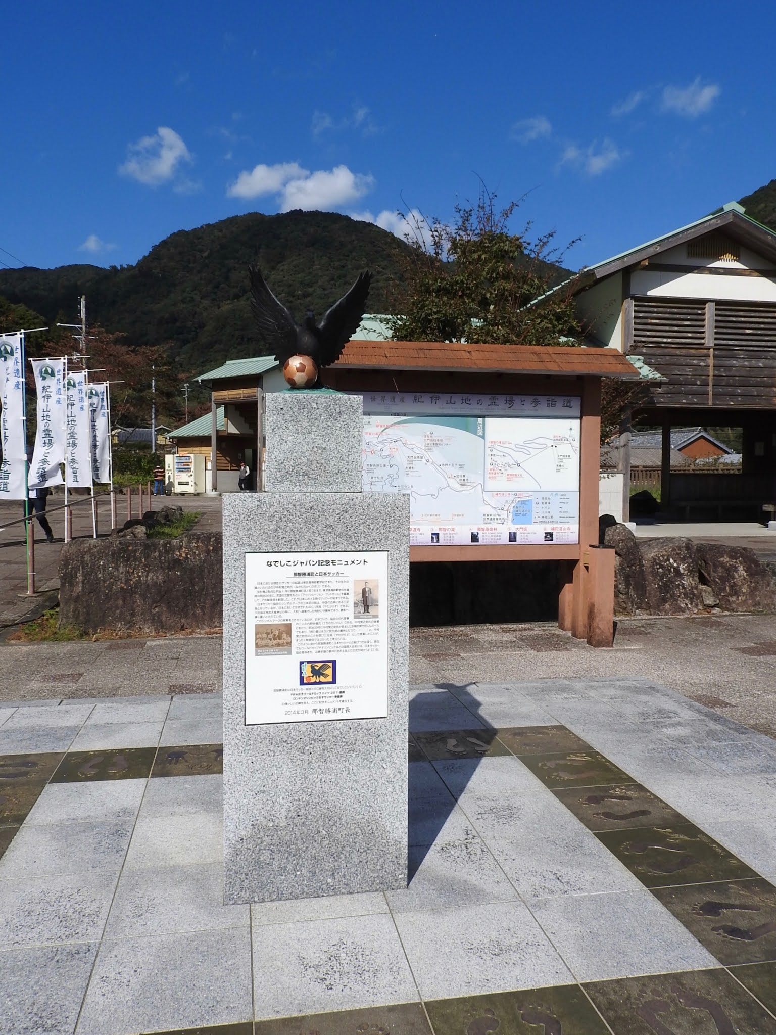 |
| 願い 天武天皇(? - 686 / 在位 : 673 - 686) が熊野に通って 蹴鞠 (ケマリ / シュウキク) をよくしたことにちなみ、 よくボールをゴールに導くようにとの 願いが込められているそうです。 Hope It is said that Emperor Tenmu (? --686 / reign: 673 - 686) often went to Kumano and improved his Kemari, and nowadays footballers hope that Yatagarasu would often lead the ball to the goal. According to Wiki about Kemari, "Kemari is an athletic game that was popular in Japan during the Heian period. Kemari has been revived in modern times." |
ヤタガラスは、たくさんのシンボルマークに使用されていたり、何かのためにデザイン化されています。
ここには、その中から3つ載せます。
Yatagarasu is used for many symbol marks and is designed into some things in Japan.
Here are three of them.
 |
| サッカー日本代表のマスコット このシンボルマークは、1921年、大日本蹴球協会 (ダイニッポンシュウシュウキョウカイ / 日本サッカー協会の前身) 創設に 尽力した内野 台嶺 (ウチノ タイレイ / 1884 -1953) らの 発案を基に、日名子 実三( ヒナゴ ジツゾウ / 1892 - 1945 )が デザイン化し、1931年に採用されました。 当時にしては、モダンなデザインに思えますし、 今の時代を思うと、温かみがあるデザインに感じます。 Japan National Football Team Mascot This symbol mark is based on the idea of Tairei Uchino (1884 - 1953) and others, who strived for founding of the 'Greater Japan Football Association' (the predecessor of the 'Japan Football Association') in 1921 and the mascot was designed by Jitsuzo Hinago (1892 - 1945) and adopted in 1931. It seems to be a modern design for those days, and when I think about the present era, it feels like a warm design. 画像は下記より / This from below ★ |
 |
| 陸上自衛隊中部方面情報隊 Japan Ground Self-Defense Force Middle Army Military Intelligence 画像は下記より / This from below ★ |
 |
| 陸上自衛隊中央情報隊 Japan Ground Self-Defense Force Military Intelligence Command 画像は下記より / This from below ★ |
0 件のコメント:
コメントを投稿